
Georgia: Brasstown Bald (4,784ft)
|
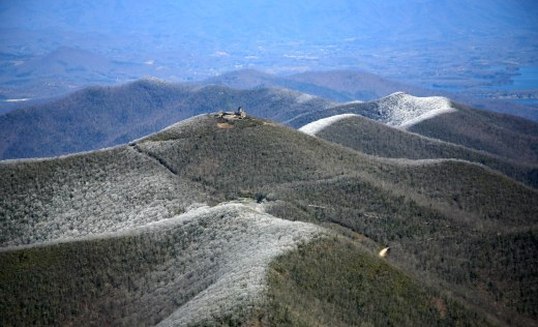
Highpoint detailsBrasstown Bald is the highest natural point in the state of Georgia, USA, with a summit elevation of 4,784 feet (1,458 m) above mean sea level.
The mountain is known to the native Cherokee people as Enotah.[2] It is named for the former Cherokee village of Brasstown, Georgia, located along the upper Brasstown Creek. Across the North Carolina state line, immediately to its north, is Brasstown, North Carolina, in the Brasstown township of Clay County, North Carolina. Brasstown Bald is partly in Towns and partly in Union counties, the peak being divided by the county line. The mountain is part of the Blue Ridge Mountains (part of the Appalachian Mountains), and within the borders of the Blue Ridge Ranger District of the Chattahoochee National Forest. The mountain is mostly made up of soapstone and dunite. On a clear day, it is possible to see the tall buildings of Atlanta from the summit. The U.S. Forest Service has webcams atop the observation tower, and a RAWS weather station further down the mountain. The public can drive to the top via Georgia state route 180 Spur. From the northeast, starting at the intersection of Owl Creek Road and the concurrent Georgia 17 and Georgia 75 near Mountain Scene, the climb is 13.5 kilometers (8.4 mi) long, gaining 828 meters (2,717 ft). From the southeast, starting at the intersection of Georgia 180 and Georgia 17/75 near Sooky Gap, the climb is 13.1 kilometers (8.1 mi) long, gaining 790 meters (2,592 ft), an average of 6.0% grade. From the west, starting at the intersection of Georgia 180 and Georgia 348 near Choestoe, the climb is 14.9 kilometers (9.3 mi), gaining 856 meters (2,808 ft), an average of 5.7% grade. From the intersection of Route 180 and Route 180 Spur at Jacks Gap the climb is 4.9 kilometers (3.0 mi) at an average gradient of 11.2%, (height gain: 551 meters (1,808 ft)). According to the two Georgia historical markers, the area surrounding Brasstown Bald was settled by the Cherokee people. White settlers derived the word Brasstown from a translation error of a Cherokee word. Sounding very similar to another Cherokee word, settlers confused the word "Itse'yĭ" (New Green Place or Place of Fresh Green) with "Ûňtsaiyĭ" (Brass). Itse'yĭ, New Green Place, is a Cherokee locative name given to several distinct areas in the Cherokee world, including an area to the North of Brasstown Bald in North Georgia. Cherokee legend tells of a great flood that swept over the land. Everyone that inhabited the land died except a few Cherokee families that sought refuge in a giant canoe. The canoe ran aground at the summit of the mountain. Having no wild game to hunt and no place to plant vegetation, the Great Spirit killed all of the trees on the top of the mountain so the surviving people could plant their crops. They continued planting until the water subsided.[citation needed] While the Cherokee legend tells of a treeless mountain top, the term "bald" is common mountain terminology describing mountaintops that have 360-degree unobstructed views. The official name that includes the word Bald in this case was not intended to suggest a once-treeless mountaintop, the way the term is used for most other Appalachian balds. |
trip detailsThis is where the admin will fill in strategic details about the high-point. Roughly when it will occur (until a solid date is picked).
Trip Leader: Nearest Base: Projected Date: Difficulty: Describe how rules are followed: Safety Plan Outdoor Recreation Contacts Chaplains Size/Mix of Group Wounded Warriors Media Outreach |
All trip updates and progress will be posted in the blog below