Pennsylvania: Mt. Davis (3,213ft)
Ranked #33/50
COMPLETED: 15 Nov 2014
Highpoint detailsMount Davis (3,213 ft or 979 m) is the highest point in Pennsylvania. Located in the 5,685 acres (2,301 ha) Forbes State Forest near the hamlet of Markleton in Elk Lick Township,
Somerset County, it lies on a gentle crest of a 30-mile (50 km) ridge line extending from central Somerset County southward into Garrett County, Maryland known as Negro Mountain. The high point was named for John Nelson Davis, an early settler, American Civil War veteran, surveyor, and naturalist known for his studies of the mountain's flora and fauna. During the Civil War, Davis served in the 102nd Regiment, Pennsylvania Infantry, Company E.[3] The summit of Mt. Davis may be ascended by car or a number of hiking trails. Its surrounds are noted for their patterns of unusual circular stone formed by periglacial action. A metal observation tower with a relief map of the region stands near the true high point. Weather on the peak is pleasant in the summer, and quite harsh in the winter. It is characterized by heavy winds, rain, and hail in the summer, to ice storms and blizzards in the winter. Temperature extremes range from −36 to 29 °C (−33 to 84 °F), though frosts have been recorded in every month of the year. Summer conditions are generally mild and winters are characterized by a lot of snowfall. Average annual precipitation ranges from 38 to 42 inches (970 to 1,100 mm). Mount Davis has a humid continental climate that is affected by the high elevation significantly enough that the area feels slightly more like a cooler version of the climate zone during the winter months. Due to its high elevation, the area is colder much of the winter than Altoona, Johnstown, or State College, despite being well south of either location. During the summer months, the area is a retreat for other Pennsylvanians with high temperatures averaging around 15 degrees cooler than Pittsburgh and eastern portions of the state. Mount Davis recorded many impressive record lows and is quite close to the state's all time coldest temperature. |
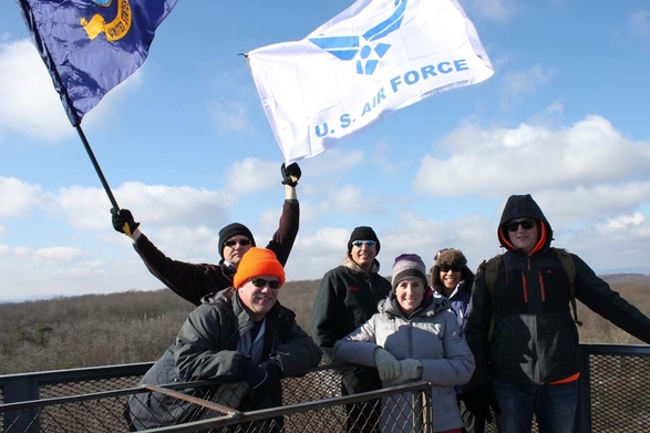
trip ReportA small group of Air Force and Navy Reservist braved the frigid temperatures this morning to complete part of the USAF 50 Summits Challenge by summiting the highest point in Pennsylvania, Mt Davis.
From the Air Force Reserve 910th Medical Squadron we had Maj Susan Gutlove, NC and Maj Lance Williams, MSC, Chief Administrator, and his spouse, Ms Julie Williams. Maj Williams served as the summit organizer. From the Navy Reserve NOSC (Navy Operational Support Center) Pittsburgh we had ENC (EXW/SW) Steve Taylor, Command Chief; DC2 (SW) Joshua Capasso, Command Career Counselor, which both are Active Duty FTS (Full Time Support) for the center, and ETC Scott Provance, CNE-CNA-C6F MPP Det 205, Senior Enlisted Advisor. Bad weather and cold temperatures ended up keeping a lot of folks away from the summit. The Northern parts of PA and OH had received the first major snow storm of the season and presented ice road conditions for those driving in. It was a toasty 19 degrees as we began our hike up to the summit, but it was a bright and sunny day. The group parked at the Mt Davis picnic area and prepared for the hike over to the summit, which was just over a mile away. Once at the summit, we made the climb to the top of the fire tower to take pictures. The metal on the tower was so cold, anything wet touching it, instantly froze to it, but oddly no one accepted the challenge to put their tongue on it. While we were taking picture on top of the tour, we meet a couple from Savannah, GA that was traveling to see the Georgia Southern vs Navy game that weekend, which made our Navy side excited. For the record, Navy beat Georgia Southern 52-19. Once we had completed the summit, the group broke in two to complete a 4 mile loop around the high point. Chief Provance and Ms Williams took off on a trail run, while the rest of us opted to hike the trail, and Maj Gutlove headed back to her car for the long drive back to Ohio. The high point area had some beautiful trails and scenery. After we departed Mt Davis, we headed down the mountain to grab some lunch before headed our separate ways. It was a great day and all we excited to do it again next year, but perhaps in some better weather! The high point area will definitely support a run/trail run, which could be added for the next adventure here. Mt Davis is within about 30-40 minutes of the Flight 93 National Memorial, and about an hour from the Maryland high point. If accessing Mt Davis from the Somerset, PA side, you pass several impressive wind mill farms too. |


