
Tennessee: Clingmans Dome (6,643ft)
|
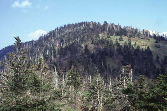
Highpoint detailsClingmans Dome (or Clingman's Dome) is a mountain in the Great Smoky Mountains of Tennessee and
North Carolina, in the southeastern United States. At an elevation of 6,643 feet (2,025 m), it is the highest mountain in the Smokies, the highest point in the state of Tennessee, and the highest point along the 2,174-mile (3,499 km) Appalachian Trail. East of theMississippi River, only Mount Mitchell (6,684 feet or 2,037 metres) and Mount Craig (6,647 feet or 2,026 metres) are higher. Clingmans Dome has two subpeaks: 6,560-foot (2,000 m) Mount Buckley to the west and 6,400-foot (1,950 m) Mount Love to the east. The headwaters of several substantial streams are located on the slopes of Clingmans Dome, namely Little River on the north slope, and Forney Creek and Noland Creek (both tributaries of the Tuckasegee River) on the south slope. The mountain is located entirely within the Tennessee River watershed.[3] Clingmans Dome is protected as part of the Great Smoky Mountains National Park. A paved road, closed from December 1 through March 31,[3] connects it to U.S. Highway 441(Newfound Gap Road). The concrete observation tower, built in 1959, offers a panoramic view of the mountains in every direction. An air quality monitoring station, operated by the Environmental Protection Agency, is the second highest in eastern North America. Reputedly known as "Kuwahi" (the mulberry place) by the Cherokee Indians, the mountain was dubbed "Smoky Dome" by American settlers moving in from other areas. In 1859, the mountain was renamed by Arnold Guyot for compatriot Thomas Lanier Clingman[4] (1812–1897), an American Civil War general who explored the area extensively in the 1850s and then spent many years promoting it. Guyot named the mountain for Clingman because of an argument between Clingman and a professor at the University of North Carolina, Elisha Mitchell, over which mountain was actually the highest in the region. Mitchell contended that a peak by the name of Black Dome (now known as Mount Mitchell) was the highest, while Clingman asserted that Smoky Dome was the true highest peak. Guyot determined that Black Dome was 39 feet (12 m) higher than Smoky Dome. Clingmans Dome is the most accessible mountain top in the Great Smoky Mountains National Park. Closed from December 1 through March 31,[3] the 7-mile (11 km) Clingmans Dome Road begins just past Newfound Gap and leads up the mountain to the Forney Ridge Parking Area, 300 feet (91 m) below the summit. A half-mile (800 m) paved trail leads from the parking lot to the 54-foot (16 m) observation tower at the top of the mountain.[9] The short, steep trail provides a small visitor information center and park store staffed by the Great Smoky Mountains Association, garbage cans, and numerous benches to the side of the path. Vault toilet restrooms are available. The trail offers a glimpse of the often hostile environment of highland Appalachia, passing through the spruce-fir forest and its accompanying blowdowns and dead Fraser Firs. The observation tower allows spectators a 360 degree panorama of the surrounding mountains, on the infrequent occasion of a clear, sunny day. Cantilevered signs, hanging from the rails of the tower, point out the various peaks, ridges, cities, and other features visible in the distance. Depending on the haze, visibility ranges from 20 miles (32 km) on hazy days to 100 miles (160 km) on very clear days. The Appalachian Trail crosses Clingmans Dome, passing immediately north of the observation tower. A 7.5-mile (12.1 km) leg of the trail connects the mountain with Newfound Gap, and provides the only non-overnight access to the mountain in winter months. The nearest A.T. backcountry shelters are the Double Spring Gap Shelter, which is 2.6 miles (4.2 km) to the west near the Goshen Prong junction, and the Mount Collins shelter, which is 4 miles (6.4 km) to the east near the A.T.'s Sugarland Mountain Trail junction. Clingmans Dome is the base for several additional hiking trails, including the Forney Ridge Trail (to Andrews Bald) and the Forney Creek Trail (to the Benton MacKaye Trail on the shores of Fontana Lake). The western terminus of the Mountains-to-Sea Trail, which connects the Smokies to the Outer Banks of North Carolina, is located atop Clingmans Dome. It follows the Appalachian Trail for 3.8 miles (6.1 km) to the east, where it then begins to descend toward the Blue Ridge Parkway, via the Fork Ridge Trail. |
trip detailsThis is where the admin will fill in strategic details about the high-point. Roughly when it will occur (until a solid date is picked).
Trip Leader: Nearest Base: Projected Date: Difficulty: Describe how rules are followed: Safety Plan Outdoor Recreation Contacts Chaplains Size/Mix of Group Wounded Warriors Media Outreach |
All trip updates and progress will be posted in the blog below