COMPLETED: 25 SEP, 2015
Vermont: Mt. Mansfield (4,393ft)
Ranked #26/50
Highpoint detailsMount Mansfield is the highest mountain in Vermont with a summit that peaks at 4,393 feet (1,339 m) above sea level. The summit is in Underhill; the ridgeline, including some secondary peaks, extends into the town of Stowe, and the mountain's flanks also reach into the town of Cambridge.[3]
When viewed from the east or west, this mountain has the appearance of a (quite elongated) human profile, with distinct forehead, nose, lips, chin, and Adam's apple. These features are most distinct when viewed from the east; unlike most human faces, the chin is the highest point.[4] Mount Mansfield is one of three spots in Vermont where true alpine tundra survives from the Ice Ages. A few acres exist on Camel's Hump and Mount Abraham nearby and to the south, but Mount Mansfield's summit still holds about 200 acres (81 ha). The mountain is used for various recreational and commercial purposes. "The Nose" is home to transmitter towers for a number of regional radio and TV stations. There are many hiking trails, including the Long Trail, which traverses the main ridgeline. In addition, the east flank of the mountain is used by the Stowe Mountain Resort for winter skiing. A popular tourist activity is to take the toll road (about 4 miles (6.4 km), steep, mostly unpaved, with several hairpin turns) from the Stowe Base Lodge to "The Nose" and hike along the ridge to "The Chin." Along with other expert trails, a group of trails, known as the "Front Four", are Goat, Starr, National and Liftline. They have steep pitches, many natural hazards (rocks and trees), and little grooming. There are also cross country ski trails around the base of the mountain and on its lower slopes. The Bruce Trail descends the east side of the mountain while the Teardrop Trail descends west side. In addition to Stowe Mountain resort, Skiing is also available at the nearby Smugglers' Notch Resort. Mount Mansfield has several hiking trails which lead to the summit. They range in difficulty from M (moderate) to DDD (very difficult).[6] The easiest trail, rated M though exposed to the elements, begins at the Visitor Center at 3,950 feet (1,204 m) near the top of the Toll Road and continues north, following the part of Vermont's Long Trail along the tundra ridgeline, reaching the summit after 1.5 miles (2 km). An alternative to driving or walking up the Toll Road is to hike up the Haselton Trail (rated D), which starts at the base of the gondolas near Rt. 108, and ends on the Toll Road not far below the Visitor Center. More difficult is to follow the Long Trail from the other end, a steep and rocky climb (rated DD) that starts on the west side of Rt. 108 less than a mile north of the Stowe Mountain Lodge (the trailhead is labelled "Long Trail South"). The Profanity Trail (rated DD) starts near the top of the Long Trail climb, but instead of going directly to the summit, it ends on the Long Trail on the other side of the summit, the part along the ridgeline. Finally, the short (0.7 miles (1 km)) but very difficult Cliff Trail (rated DDD because it involves scrambling up boulders and walking along ledges) starts at the Cliff House Restaurant at the top of the gondola and ends on the Long Trail along the ridgeline not far from the summit. Finally, there are several other hiking trails approaching the ridgeline from the west. The name comes from the dissolved town of Mansfield, Vermont, in which the mountain was located. It was common for settlers to name Vermont towns for their previous homes; several of the original grantees were from Mansfield, Connecticut, which in turn is known to have been named for Moses Mansfield, one of the chief landowners there. The Town of Mansfield was platted before anyone involved had visited the site; when it was surveyed, it was discovered to be mostly mountainside. Although a few hardy pioneers settled in the town's few lowlands, the town was dissolved by degrees, with the portion generally west of the mountain being annexed to Underhill in 1839, the eastern portion to Stowe in 1848 after a vote of the citizenry. The dividing line did not run exactly along the ridge of the mountain; thus, the Chin is in Underhill and the Nose in Stowe. |
trip detailsTrip Leader: SSgt Chris LaBerg
Nearest Bases: Burlington ANG, New Boston, Schenectady ANG Projected Date: 25 Sept 15 Difficulty: Moderate Hike TRIP REPORT:
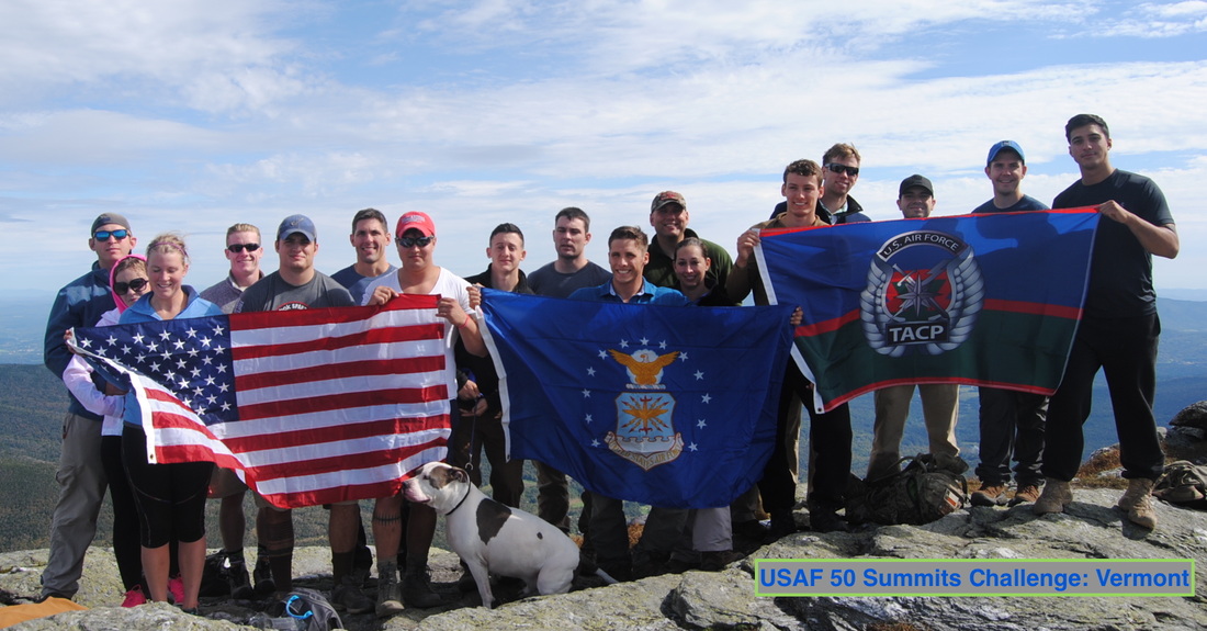
Eighteen Airmen from Ft. Drum, New York hiked to Vermont's highest point, Mt. Mansfield, on Sept 25th, 2015. Led by SSgt Chris LaBerge of the 20th Air Support Operations Squdaron, this group of Air Force members hiked together as an opportunity to build healthy resiliency skills and to show their pride in serving their country. This was much more than a hike up a hill. 24 hours earlier, the team of Airmen was joined by dozens of other service members for a day of discussion and presentations on the different pillars of resiliency. Thanks to chaplains and mental health professionals from Ft. Drum, the Airmen were able to learn about and consider different views on the importance of spiritual, social, physical, and mental health. SSgt LaBerge reported they focused on stress management such as "avoiding catastrophic events (your spouse is 30 minutes late, how do you avoid thinking they're dead, cheating, etc)." His team also learned about "mental resiliency with frame of mind, talking yourself up to increase your performance (common with snipers and athletes, believing you can do something and then doing it)." "They emphasized on spiritual not being religion, but something to find peace of mind with, nature, golf, stuff like that." The learning didn't stop there. Unlike many military mental health events that end after a classroom session, this group of Airmen headed outdoors to practice what they had just learned. Many experts agree: resiliency is not something that can be taught from a book or presentation. Rather, it must be practiced over and over, often in challenging circumstances. The team chose Mt. Mansfield and it's miles of hiking to practice their skills and build up camaraderie. The diverse group worked together during the five hour hike to ensure all who started reached the top. On the summit, they proudly flew the American, Air Force, and TACP flags. Mission Complete! SSgt LaBerge said that it was such a success that he and his colleagues aim to do another resiliency hike, but this time it will encompass three state high points: RI, CT, and NJ. We wish them luck and will help spread the word about this morale and health boosting event they are organizing. |


