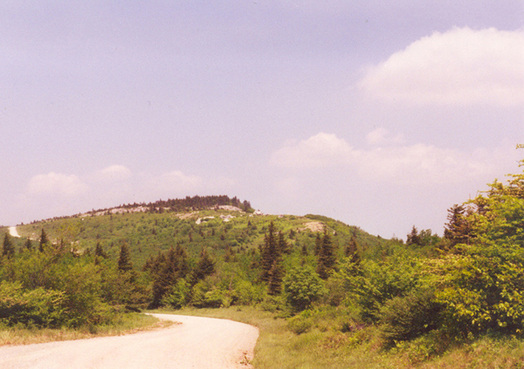
West Virginia: Spruce Knob (4,863ft)
|
Highpoint detailsSpruce Knob, at 4,863 feet (1,482 m),[1] is the highest point in the state of West Virginia and the summit of Spruce Mountain, the highest peak in the Allegheny Mountains
The summit of Spruce Knob has a definite alpine feel, much more so than most other mountains of the Southern Appalachians. The upper few hundred feet are covered in a dense spruceforest, a relic boreal forest environment similar to those found in northern New England and Canada. The summit is accessible both via trails and a paved Forest Service road, and is crowned with a stone lookout tower amid a mixture of boulder fields, meadows and trees. A handicap-accessible nature trail half a mile (0.8 km) long circles the topmost part of the mountain. High west winds near the summit have gnarled the spruce there like Krummholz, flagged with limbs only on their leeward (eastward) side. Geologically, Spruce Knob is formed of a resistant bed of Pennsylvanian Pottsville Sandstone. As is typical in the southern Appalachians, the highest point on a ridge is frequently referred to as a knob or dome. Spruce Knob is the highest point along a ridge known as the Allegheny Front. Dropping steeply to the east, it offers views of the Germany Valley and North Fork Mountain; to the west is the Allegheny Plateau. It also is the highest point in the Chesapeake Bay Watershed. Paved access is from U.S. Route 33/West Virginia Route 28 about 2 miles (3.2 km) south of Riverton. Briery Gap Road (County Route 33/4), Forest Road 112 and Forest Road 104 have been reconstructed and paved to provide a hard-surfaced road to the summit. Spruce Knob is within the Spruce Knob-Seneca Rocks National Recreation Area, which in turn is part of Monongahela National Forest. Established in 1965, it was the first National Recreation Area designated by the U.S. Forest Service and includes more than 100,000 acres (40,000 ha). There are over 75 miles (121 km) of hiking trails around the mountain and a small 25-acre (10 ha) lake well stocked with trout on the west side of the mountain. Two campgrounds are also on the mountain.[3][4] |
trip detailsTrip Leader: Maj Chris Wilson (requesting a 2nd trip leader- please contact us if you are interested!)
Nearest Base: Andrews AFB, MD and 167th Airlift Wing, WV Air National Guard Projected Date: 30-31 May 2015 Difficulty: Moderately Strenuous (long hike and 3000'+ total elevation gain) PRIMARY PLAN Saturday: Meet at 1000-1100 and begin hike NLT 1200 (18 miles). Camp along the way near Seneca Creek. Sunday: Leave for the summit early with bouldering opportunities near top. Summit and and hike back to vehicles. (Possible for vehicle shuttle depending on parking) Wounded/Disabled Warriors: if mobility challenged meet at summit via the Spruce knob road. If unable to hike 8+ miles, then can hike from the top and meet group at designated time. Trip Leader will have cell phone in order to coordinate. Contact us to work out a customized plan- we aim to get anyone to the top! (If anyone would like to arrive on Friday, 29 May, there are camping options at Spruce Knob lake very close by to the trailhead...please email for details) |
All trip updates and progress will be posted in the blog below

